


Glimpses of the area’s pristine past line our inland waterways
By Bill Newcott
Photograph by Kim Johnson
From the September 2022 issue
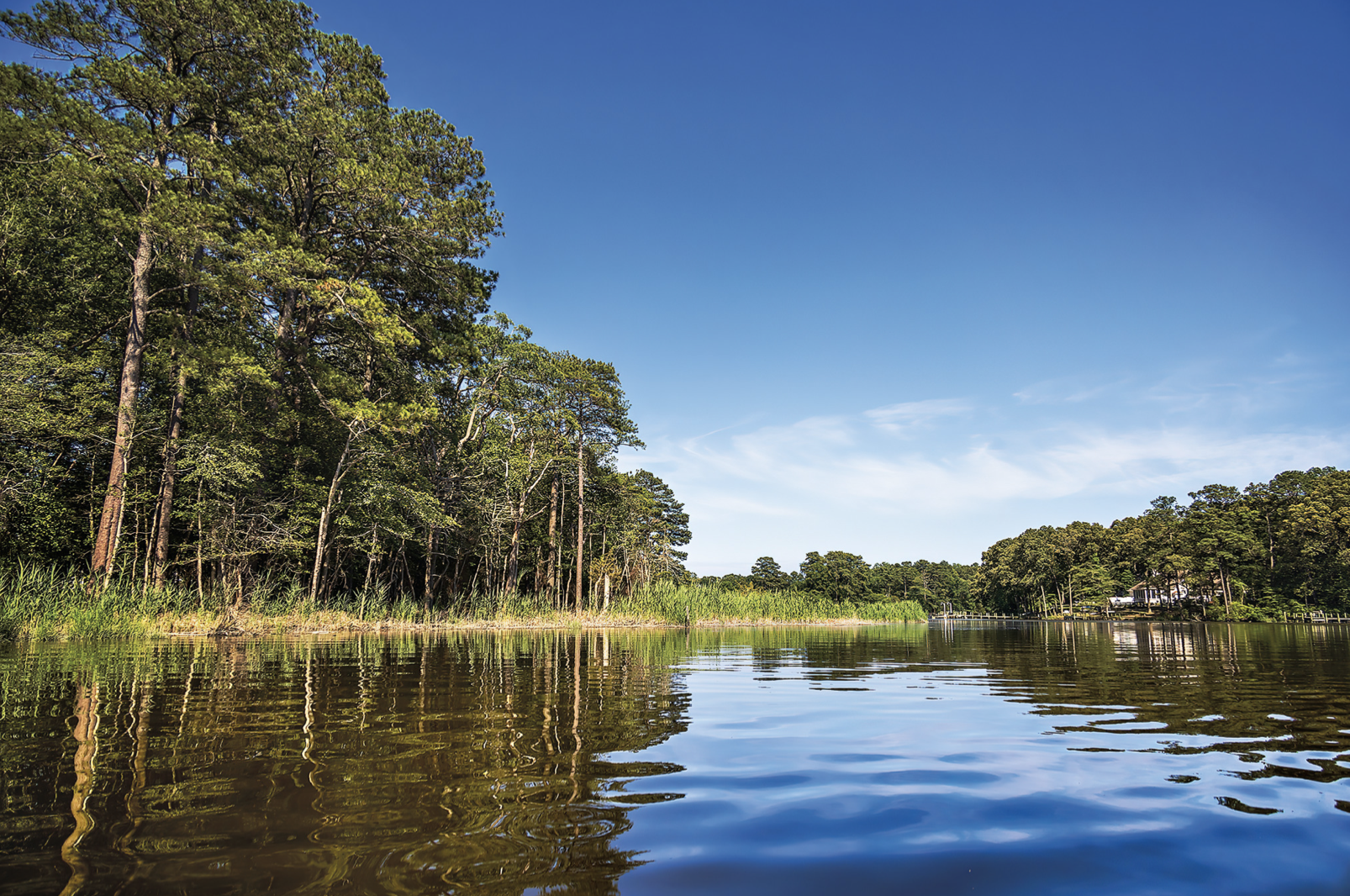
The shorelines of Love Creek are drawing closer to my kayaking companions and me, like a green curtain being pulled across a watery stage. We left the last flock of laughing gulls wheeling over the creek a good half-mile back, their cacophony now absorbed by the broad-leafed trees hanging over our heads.
I make a sharp turn — nearly too sharp for my 9-foot kayak — and spot a large log lying across the stream.
“This might be it,” I shout. Fortunately, there’s a slip of a channel off to the left of the log. It doesn’t take too much wriggling to push through it. Just maybe, we can keep going until this creek is too narrow for even our pointy little boats.
And if we’re really lucky, we just might make it to the end. Or, depending on your perspective, the beginning.
There’s something about going upstream; something about seeking headwaters, no matter how modest. While it’s true that Homo sapiens may well be the only creature that imagines a far-off future, there’s also no denying humans harbor a unique fixation on origins: Where did we come from? When did the universe start?
And where does this river begin?
Each year, hundreds of thousands of tourists dip their toes into Grand Lake, near the northern end of the Colorado River. They drive hundreds of miles out of their way for a look at Lake Itasca, Minn., the source of the mighty Mississippi. Decades ago, I sat in my office at National Geographic magazine listening to four extremely excited young men describe their dream of riding mountain bikes through the uncharted jungles of Brazil and Peru, hacking a machete-cleared path to the source of the Amazon.
Of course, I told them (as kindly as possible) that their idea was bat-guano insane. Yet, as they left, utterly undiscouraged, I felt a charge of excitement.
“It’s impossible,” I thought, “but wouldn’t it be cool?”
A similar, if more subdued, sense of adventure flits across my mind every time I drive across the Indian River Bridge, glancing westward at the green horizon, imagining what sits at the uppermost point of each watery tendril that feeds into the bay. Motoring around coastal Delaware, everyone sees the broad expanses of Love Creek and the Broadkill River and Canary Creek — but it’s what’s beyond that first turn, the unseen contour of a meandering course, that tempts me.
And so I decided I would pick a couple of well-known, mostly tidal creeks — appreciated by local folks primarily for their wide lower regions — and follow them upstream as far as I could.
I wasn’t looking to be Lewis and Clark, and I made my friends promise we would not devolve into a “Heart of Darkness” scenario (and don’t get me started on “Deliverance”). In Sussex County alone, there are nearly 1,000 miles of creeks and streams, often embedded within newly built communities, gurgling virtually unnoticed by people living mere yards away from them.
We would start out bobbing in the broad, choppy realm of motorboats and Jet Skis. I imagined pushing inland, weaving among the meandering blue lines I’ve studied so many times on Google Maps. In a place where, increasingly, a woodland is considered an undeveloped eyesore and an active farm a waste of real estate, would those sheltered, braided waterways provide even a hint of the Delaware of decades past, the one I missed out on?
We must get one thing straight: I paddle a kayak, but I am not a kayaker. If you’re looking for a piece by one of those guys who calls his life jacket a PFD (personal flotation device) or who waxes poetic about reading the riffles of a river or the time he tried to negotiate an Eskimo roll but ended up doing a “carp” instead, then I suggest you skip this story right now.
Let’s put it this way: My friend Bill paddles a Wilderness Systems Pungo (“delivering a dynamic on-water performance with superior stability and unmatched speed,” according to the manufacturer). My friend Greg is in an Elie Sound 100 (created with a “thermoforming process that fuses together the deck and the hull … to create unusually high strength and a single-piece feel.”)
And here I am in my L.L. Bean Manatee kayak, named for the single least streamlined creature on the planet — a seagoing dumpling, really (though my craft is praised as “super stable and fun!”). It is the color of an orange construction cone, as if to warn other kayakers: Danger — Nerd Ahead.
The three of us are paddling around the point just south of the MERR (Marine Education, Research & Rehabilitation) Institute near Lewes. Here is a Grand Central Station of four waterways: the Roosevelt Inlet, the Broadkill River, the Lewes-and-Rehoboth Canal and Canary Creek — with working fishing boats, lazy pontoons, scientific research vessels and Delaware River pilots crisscrossing a compact intersection. After having put in at the Lewes Public Boat Ramp, we’re riding the perpetual chop, just trying to round the curve to the creek.
“You’re so cute!” a sunglassed woman in a baseball cap shouts to me as her 20-foot NauticStar deck boat passes by. “We started out just like you! In little boats! And look at us now!”
She throws her head back, like Jackie Onassis on the bow of hubby Aristotle’s Christina O. I smile and paddle on.
Pilottown Road crosses Canary Creek just a few yards in from the little harbor, a low-slung rectangle of concrete that, at low tide, offers us about 5 feet of clearance. A man in a white hat and blue sweatshirt is fishing on the side facing the harbor.
“Catch anything?” my friend Bill shouts.
“Just a few kayakers,” he says with a laugh, and we steer far to his right, avoiding his line. I notice that the electric and phone lines passing high over the bridge are festooned, tinsel-like, with scores of fishing lures and bobbers, victims of errant casts.
Slack tide is just ending, so a gentle current is helping us move upstream. This is the part of Canary Creek most people are familiar with: wide and calm, grasses shooting up on both sides, rooted atop a steep, muddy bank that drops 2 or 3 feet to the water. Above the swaying grass, to our left, we spot the head of an American bald eagle that’s sitting on a lone tree stump.
We’re paddling through the southeastern tip of the Great Marsh Preserve, 17,000 precious acres of coastal wetlands bordered by towering stands of trees. For the moment, at least, there’s not a human-made structure to be seen — except for the University of Delaware wind turbine, at 400 feet in height virtually inescapable from any point miles around. I am aware of four distinct sounds: the gurgle of my paddle in the water, the song of birds, the rustle of grass in the wind … and the soft whoosh of those seven-ton, 144-foot-long blades.
Then there’s another sound, one that repeats itself every time we make a turn in this meandering creek: the splash of turtles diving for safety from we three floating interlopers. They’ve been sunning on the steep banks or at their base, and the sight of our kayaks never fails to throw them into a panic.
“Holy cow,” says Greg. “Look at ’em all!”
At that moment, I realize we are surrounded by tiny heads breaking the surface tension of the slow-moving creek — hundreds of turtles, swimming about us like survivors of a cruise ship wreck waiting to be rescued. They are everywhere.
“Diamondback terrapins,” says Greg, who knows about this stuff. These little guys are the only strictly estuarine turtle in North America, which means they thrive in the web of creeks that snake across our coastal landscape. As we paddle upstream, every sun-facing cove is teeming with turtles that, at the first hint of our presence, leap from their low perches like herds of squat migrating wildebeests. By the end of our journey we’ll have easily seen thousands of them.
But there’s more movement on the banks, in the muddy cliffs above the turtles. At first glance, it appears the entire landscape is moving; undulating in upward waves. A closer paddle reveals the truth: I’m seeing countless, teeny fiddler crabs; thousands of them in a few square yards, retreating to their little creekside holes. Aside from, maybe, ants around their hills and bees in their hives, I’ve never seen such a concentration of critters in one place.
The retreat lasts mere seconds. In moments, every crab seems to have ducked into a hole — save for a few brave souls who stand their ground, shaking their single, oversized claw at us like bony clenched fists.
This chaotic scene will repeat itself every few yards, on both sides of Canary Creek, nearly as far as we travel upstream. All in all, it doesn’t appear the crabs and turtles see many kayakers in these parts.
Canary Creek, like most creeks on flat terrain, doubles back on itself every hundred yards or so. As a result, while the University of Delaware turbine most often looms to our left, it sometimes shifts to our right and occasionally to our rear. Presently, we happen upon a few houses to our right, built in a development along Creekside Drive. Here the creek suddenly becomes uncharacteristically straight — apparently dredged out in some long-ago, misbegotten attempt to tame nature.
Up ahead is the New Road bridge, and that’s my clue to start looking for the highlight of this route. To our left, I spot it: a narrow stand of trees growing from a 700-foot-long causeway.
This is the Pagan Creek Dike, built by Lewes’s first Dutch settlers in the mid-to-late 1600s. It was actually a causeway made of clay, loam, sand and timbers, created to give the settlers access to the creek. Structurally, the dike was a direct descendant of the massive dike network built to hold back the sea in the Netherlands. You can see the dike from the New Road bridge, but only from a kayak or canoe, at low tide, can you spot remnants of the original timbers, still in remarkably good shape.
“Pagan Creek” was the unfortunate name the European settlers gave this waterway, inspired by what they considered the spiritual state of the people they found here. Later arrivals apparently thought better of it and rechristened the stream Canarkill, Dutch for Canary Creek, in honor of the yellow finches that flitted along its banks.
Almost directly across the creek from the dike, a startling vision catches my eye. For a flash, the tumble of starched, bony shells, piled atop each other from the waterline to a ridge 5 feet or so above, resembles those temples made of human skulls you’ve seen in “Weird World” books. They look like miniature conch shells, but Bill knows better.
“Whelk shells!” he declares, and he paddles closer for a better look. There are hundreds of the things here, and I remember someone telling me the Lenni Lenape people used to harvest them right around here, leaving mounds of shells behind.
“These would look great in our garden,” he adds.
“We probably shouldn’t touch them,” I say with unearned authority. “This may be an ancient midden.”
Well, of course I was wrong. Mostly. I’d later contact Marcos Salaverria, director of education for the Lewes Historical Society, and he would set me straight.
“This area was a popular fishing ground for the Lenni Lenape people because the whelks shelter along the shore here,” he told me. “But it’s not a Native American midden pile. Those whelk shells would not and could not stay in place with changing tides and currents.
“These are modern-day whelk shells.”
So, sorry, Bill. I owe you some whelk shells.
Just beyond the dike and the shells, about 3 miles from where put in, we reach an unpassable barrier: The bridge at New Road. The designers of bridges around here seem to have had little regard for navigation of our creeks, leaving clearances way too low for even a kayak.
There is no practical way to pull out and portage over New Road, so we paddle back downstream. At the Pilottown Road bridge, the water has risen to the point where we need to lean all the way back in our kayaks, press our hands against the underside of the bridge, and “walk” our way through.
I emerge ahead of Bill and Greg and take their picture. Turn the image sideways, and they look like Spider-Men scaling a concrete wall.
It was a fun paddle through unfamiliar territory, but something was missing: The headwaters of Canary Creek, where the course shrinks to just a few feet in width, lay beyond the New Road.
I want to get to a source; to a point where nature, and not human barriers, would say, “This is as far as you go.”
Love Creek slides under a bridge at Route 24, about 9 miles south of the Great Marsh. Four friends and I are standing in the gravel lot near the west side of the bridge, where an unmarked concrete boat launch slants into the water.
“I’ve never seen anyone get towed from here,” says some guy who happens to be there. He motions toward the half-dozen people fishing from the old, abandoned bridge that has been converted to a fishing dock.
“Those folks park here all the time.”
That’s good enough for us.
There are shamefully few public access points to coastal Delaware’s creeks, so the intrepid kayaker must occasionally, and respectfully, skirt the niceties of private-property laws. In a few minutes we’re all on the water, threading our way between fishing lines and heading upstream.
Technically upstream, that is. The tide is still coming in, so we’re riding the rising waters, planning to head back during slack tide. (Hey, just because I’m in a kayak does not mean I actually enjoy paddling, you know? If I could fit a motor on this thing, I’d be all set.)
As on Canary Creek, Bill and Greg have come along with their state-of-the-art kayaks. We’ve been joined by two more friends, James and Arnie, who heard how much fun the three of us had exploring the relative wilderness. And, yes, they both own really cool kayaks, making me feel even more like I’ve brought a Datsun B210 to the Indianapolis 500. (I’ve traded my prison-jumpsuit-orange kayak for my wife’s baby blue one. Not much of an improvement.)
For the first mile or so, Love Creek remains about as wide as it is at the bridge; a few hundred feet. The turns are wide and lazy, and houses peek at us from behind stands of trees. We encounter far fewer turtles, but a lot more birds:
A pair of pterodactyl-like great blue herons squawk angrily as we follow them upstream. Laughing gulls hover like Harrier jets, furiously beating their wings waiting for a fish to venture too close to the surface. And two bald eagles soar overhead, each of them being hassled by smaller birds that clearly do not want them in the neighborhood.
There’s a geopolitical metaphor in there someplace, but this is not a day for considering current events: The water is mirror-like; the sun is warm but not beating; the sound of Route 24 has retreated into the distance.
At a wide spot in the creek, on the opposite bank, a woman in a blue dress and dark sweater is casting a line from a dock. I paddle over. The house behind her is decidedly more modest than the enormous homes rising nearby.
“What do you catch here?” I ask.
She looks up, a little surprised that anyone has stopped to chat. Then she smiles.
“I’ve never caught anything from this dock,” she says, and throws her line in a direction away from my kayak.
“Well, how long have you lived here?”
I ask.
She lifts her eyes, calculating.
“Since 1990,” she says. And then she just watches the water.
“So, you just like being out here,” I offer.
“Oh, yes, for now, anyway,” she answers a bit wistfully. She hesitates. I sense she doesn’t want to ruin the idyll of this afternoon.
“They’ve just approved a recreational dock for a development right over there” — she points across the creek and downstream. “That’s gonna bring the Jet Skis. And then it’ll be all over.”
We’re quiet for a moment, the water slapping gently against my popsicle-blue kayak.
“Well, have a nice afternoon,” I finally say. “I hope you catch something. Or maybe not.”
Not much farther upstream, Love Creek takes on a bayou-like character, with dead trees jutting abruptly skyward and green islands of vegetation popping up unexpectedly. It’s not immediately clear where the creek heads from here — or if, indeed, there’s even a course to follow.
But there are gulls. Lots of gulls. Hundreds and hundreds of gulls, wheeling in a blizzard of white, letting out a call-and-response chorus that immediately identifies them as laughing gulls.
Gulls sit on the bare tree branches.
They float on the water. They dive for the tiny fish that have certainly lured them here. It’s a gull smorgasbord, and we are currently between bird and prey.
“I have some advice,” says Arnie. “Keep your hat on and don’t look up.”
“And don’t open your mouth,” James adds.
It takes some probing, but we find the continuation of Love Creek just to the left of the laughing gull fish feast. And it is exactly what I was hoping for: barely 3 feet wide, just deep enough to accept my kayak’s draft, under a canopy of trees.
The air temperature drops 10 degrees. Every time we think we might have reached an impasse — a fallen tree, a nearly-too-narrow passage — we manage to push through. I can see every detail of the creek bed, the water tinted red with tannin.
We have found wilderness.
Until, of course, we find ourselves in someone’s backyard. We slide past the house with its fenced-in pool and immaculate lawn. I find myself wishing someone were outside so I could ask them how often strangers come floating by. Not often, I’ll bet. At least, I hope.
The sound of occasional traffic hisses up ahead. I catch sight of another low concrete bridge, and immediately I know we’ve made it all the way to Robinsonville Road.
It’s funny how, when you write about an area enough, your stories start to fold in on each other. I now realize we are at the precise location of an old ghost story I related in these pages a few years ago, in the creek at the foot of Fiddler’s Hill. The historic Rabbit’s Ferry School is a hundred yards or so up the road — and that rushing water up ahead is the sound of a spillway over the 18th-century dam that created Burton’s Pond.
We Spider-Man our way upstream under the Robinsonville Road bridge, and for the first time on this journey, I’m aware of water rushing beneath my kayak; fresh water from the spillway. Love Creek used to push a bit beyond this point, starting at the confluence of two streams that met in the middle of what is now Burton’s Pond.
“It’s an easy ford,” announces Bill. “Let’s carry our kayaks and keep going.”
The rest of us look at one another. We’ve already paddled nearly 2 miles upstream, and to be honest, we’ve found a pretty ideal finale.
There’s room to turn our kayaks around, and we glide along the forested stream. The seagulls are still feasting. A bit further on, I look for my new friend, the world’s most patient angler.
She is still there.